By Briag McRae
Generally, it is easier to climb up steep gradients than to step down them, but in the Cinque Terre the paths ‘less travelled’ inevitably include steps. Stone stairways, that begin at sea-level, wind up between centuries-old multi-storey dwellings, step up through terraced gardens of vegetables and chickens and household lemon trees, and on up to the old farmers’ tracks.
Don’t let this put you off, the following Cinque Terre walks work well for active people with ‘lived-in’ bodies, but as with many things, preparation is key.
If your doctor or physiotherapist declares you fit, and you’re comfortable walking Adelaide’s Morialta Waterfall circuit, or from Greenhill Rd to Mt Lofty, you’re in good shape for the Cinque Terre.
Trail 587: Corniglia to Volastra
Start in the charming town of Corniglia, 100m above sea-level at the top of the zig-zagging red-brick Lardarina stairway.
Unusually for the Cinque Terre, Trail 587 begins at an easily located T-junction behind the Church of San Pietro. Also unusual is the gentle gradient of the stone steps up to Trail 586, which follows the 330m contour into Volastra. This beaten-earth path, embedded with steppingstones and occasional flights of steps, winds through shady woodlands of evergreen oak and pine before emerging onto terraces full of Bosco, Alberola and Vermentino vines; source of the grapes they’ve been making into the Sciacchetra dessert wine since 4BCE.
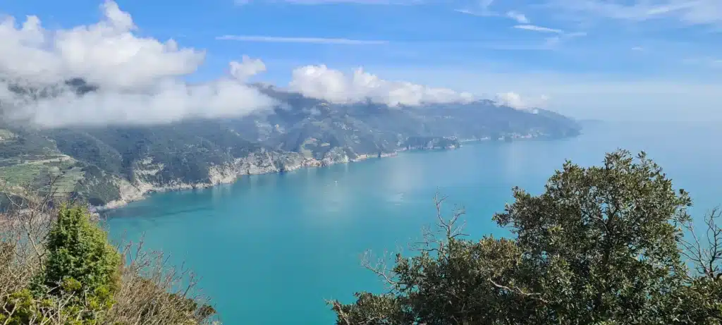
This delightful ‘warm-up’ walk affords sweeping views from Corniglia to Genoa and snow-capped Alpine peaks in the north, while to the south, Manarola looks like pastel cream topping on a rocky cup-cake.
Trail 506: Volastra to Manarola
You can taste local wines in one of Volastra’s ‘locanda’ before continuing downhill on Trail 506. This mule-track meanders between the rosemary-hedged olive groves which gave rise to ‘Vicus Oleaster’, village of the olive, later shortened to Volastra. Shallow steps become more frequent as you descend to the T-junction with Trail 502 and the left turn towards the Strada Provinciale 51 (SP51) road. A short walk along the bitumen soon returns you to the shallow steps of Trail 506 and a gentle waterside wander into Manarola.
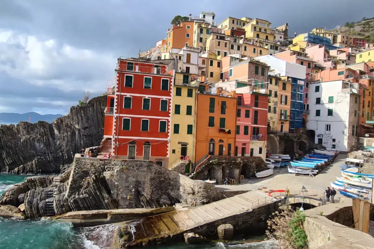
Trail 531: Manarola to Riomaggiore
Manarola’s twisting medieval passageways are a sightseer’s delight, but a more challenging walk begins uphill from the San Lorenzo church where the main road veers left and a Trail 531 sign points right. Next, find the left-pointing 531 sign on the side of a house, and head up the traditional stone steps. These are steep, with approximately 25cm high risers and 35cm wide treads.
Climb on up between houses and walled gardens, step on stones worn smooth by centuries of passing feet.
Above the town, you’ll pass abandoned terraces being revegetated by Mediterranean maquis. Modern agricultural production east of the Apennines, combined with the expensive, small-scale nature of terraced farming, have curtailed agriculture in the Cinque Terre. In the 1970’s, tourism breathed life back into the region, and the massive influx of visitors after the UNESCO World Heritage listing in 1997 prompted formation of the Parco Nazionale delle Cinque Terre, to maintain the trails and protect the environment.
Sadly, the continued deterioration of terrace walls contributed to flood and landslide damage, and nine fatalities in 2011. This tragedy led to an EU-funded ‘Stone Walls for Life’ Climate Change Adaptation project, described on a hilltop information board between Manarola and Riomaggiore.
On the other side of the hill, you’ll glimpse Riomaggiore through the trees, and have a clear view down onto the via dell’Amore, originally built as a shortcut in 1920. Landslides forced its closure in 2012, and expensive reconstruction work delayed reopening until 2024. Now tourists have to book and pay to walk this path in a guide-led group. Back on the quieter Trail 531, the earthen path with inlaid rock steps gradually becomes a continuous stairway, often with a downhill banister. Eventually the path flattens and joins the switchback road down into Riomaggiore.
Monterosso to Punta Mesco
The walk to Sant’Antonio al Mesco begins on the modern steps behind Monterosso’s concrete giant, then joins a single-lane road which switchbacks up a hillside of drowsing villas until a sign in one of the U-bends directs you to the trail.
This initially alternates between uneven rock ‘steps’ and water-eroded slopes, but is wide enough to pick a zig-zag traverse that eases the steeper sections. There are no terraces, instead the trail rises to a sandy path through mature Holm-Oak and Corbezzolo (strawberry tree) woodlands. Cross over the Levanto path junction, stroll past the Sant’Antonio al Mesco and the old telegraph station to the Punta Mesco.
This headland glories in a spectacular view of the entire Cinque Terre, all the way to Porto Venere’s southernmost islands. The way the clouds lie on the Apennines and Ligurian horizon makes it difficult to tell where the sea ends and the heavens begin; beautiful white-sailed yachts appear to sail into the sky.
Active visitors soon become adept at planning routes that use traditional steep staircases to climb up out of the towns, higher level ‘AVT’ trails to walk along the coast, and gently descending roads to return. Riomaggiore, for example, has a sign to the ‘Madonna di Montenero, 593v’ at the end of the pedestrian tunnel.
Follow red and white-painted stripes through the narrow passages and arches of the medieval town, climb the inevitable steps up past the cemetery, cross over the hair-pinned SP32, twice.
Find the main road with its ‘Solera 180 Grade’ snack bar, which boasts a terrace where you can sit, slow your pounding heart and enjoy the – you’ve guessed it – 180° view. From there, it’s only a short climb up to the Santuario.
The ongoing circuit walk continues from its western corner on ‘La Via Grande’, a wide, well-maintained mule track used for the annual procession of a painting of the ‘Assumption of Mary with the Apostles’. This trail has a calm serenity, perhaps because of the thirteen votive shrines to the Madonna along its way, or the burbling stream that accompanies the track from half-way down the hill.
The same principle of ‘steep start but gentle descent’ applies to a 12km route which begins on the stone steps alongside Porto Venere’s Castello Doria, undulates along hillsides to Campiglia, continues through Sant’ Antonio and Telegrafo, then finishes at Riomaggiore’s Santuario di Montenero. A problem with this route is its proximity to the Piccoloblu Restaurant in Campiglia, where they serve wonderfully authentic Ligurian food in a setting so delightful that a long lunch becomes more appealing than the onward trail.
A journey through history in Porto Venere
Another way to avoid the crowds is to travel in Spring or Autumn, with contingency plans for inclement weather. Porto Venere offers a host of options, one being the Church of St Peter. Archeologists discovered a polychrome marble mosaic in the part of the church by the Roman cloisters, and guessed it was the floor of a pagan temple dedicated to Venus Erycina, ancient sea goddess of fertility. Nobody knows when the church replaced the pagan temple. The stones, semi-circular apse and other architectural features are associated with the fifth century, perhaps Tino Island monks were involved in the change?
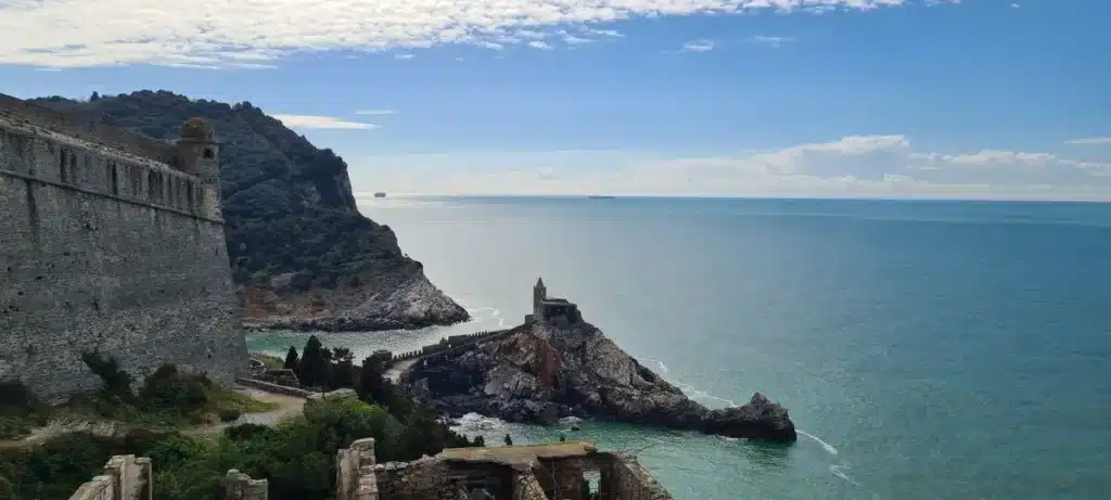
Today, the lowest stones of the little church blend into the bedrock of a promontory that reaches across the narrow sea inlet to Palmeria. The sea crashes and fumes against its confinement, and the sounds of waves and wind fill the church. It smells of marble and salt, sunlight and gloom.
There are ghostly echoes, of the Genoese adding a striking black and white marble extension in 1256, of the Aragonese bombardment in 1494, and centuries later, Austro-Russian militia’s bivouacking in the Church until they were defeated by Napoleons’ forces, who promptly melted the bells and used the church rafters as firewood. Despite all the violence and destruction of the past, today there is an intense peace in the midst of the seas’ ceaseless movement.
A visitor might sense the church walls whispering about the enduring strength of the terrace-building, trail-walking farmers of the Cinque Terre, and of their continuation of centuries-old traditions while the names of the powerful who sent men to war, have long since been lost in the mists of time.
Make sure to plan your journey, stay hydrated, and wear sturdy footwear! Access up-to-date trail statuses and download a detailed PDF map at parconazionale5terre.it